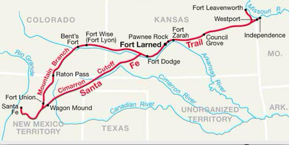
Two routes from Independence to Santa Fe. (National Park Service)
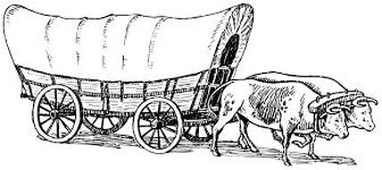 Conestoga freight wagon.
 Roger M McCoy
When the Spanish ruled Mexico, which included provinces north of the Rio Grande River, they declared that trade with New Mexican natives and colonists was illegal. During this time traders from the United States gradually traveled to trading posts farther west along the Rio Grande River, and eventually reached the Spanish territory of New Mexico. Most such traders were stopped by Spanish officials and sent home. Hence during this time there was almost no trade by Mexico City or the United States with the territory of New Mexico.
The Mexicans had lived under Spain’s dominance since 1607, more than two centuries. In their second attempt at independence the Mexicans finally won their freedom and became independent in 1821. This opened the door for anyone to trade with Mexico. Americans entered the game that same year and developed the Santa Fe Trail as a route for traders traveling from Independence, Missouri to Santa Fe, New Mexico.
The city of Santa Fe has a long and interesting history. Native Americans are known to have had a settlement in what today is downtown Santa Fe since soon after 900 A.D., making the city the oldest continuously occupied settlement in the United States.
Following the Mexican-American war in 1848 the United States acquired much of the southwest by the Treaty of Guadalupe Hidalgo, and Santa Fe became an American city in the territory of New Mexico. This further opened the region to economic development and settlement by Americans. With this, Santa Fe became an important trade center both with the rest of Mexico and with the United States.
Seeing a new opportunity, Missouri trader William Becknell wasted no time loading up several wagons and headed for Santa Fe in September 1821. With a small group of men and a cargo of goods he arrived in Santa Fe on November 16. They were welcomed with open arms by Mexican citizens and government officials and encouraged to return soon with more goods to trade. Becknell’s initial path to Santa Fe became known as the Mountain route of the Santa Fe Trail. This route also became important for stagecoach travel and mail delivery and marked the beginning of the Santa Fe Trail as we know it today.
Returning to Missouri Becknell took a shorter route along the Cimarron River which soon became the most traveled track to Santa Fe. The map above shows the Cimarron Cutoff leaving the Arkansas River at the Cimarron River near present day Dodge City, Kansas. From there it continued southwest ending in Santa Fe. The Cimarron route was about 100 miles shorter than the route through Raton Pass and less difficult. The supply of water was less reliable however and raids by the Comanches or Apaches were more common.
The route of the trail led southwest from Independence to the Arkansas River near the present site of Great Bend, Kansas (shown on the map as Fort Zarah). From there it followed the Arkansas River westward to Bent’s Fort (see Note 1) near present day La Junta, Colorado, then southward along the Purgatoire River (see Note 2) to Santa Fe. It went southward into Santa Fe across the narrow and difficult Raton Mountain Pass at 7,834 feet elevation.
Both the Mountain and Cimarron routes crossed the northwestern territory of the Comanche Tribe. In the beginning the Comanches and Apaches would not tolerate passage of wagon trains on their land and frequently attacked them. When these tribes later became an important market for American traders they then required compensation for passage through their land.
Business was booming and traffic traveling to Santa Fe along the Arkansas River became so heavy that bison herds often had difficulty following their usual seasonal migration to grazing lands.
Wagons and Draft Animals on the Santa Fe Trail.
Because the primary use of the Santa Fe Trail was hauling freight, the large Conestoga wagon was usually preferred. Why was a freight wagon called Conestoga? The name first appears regarding the Susquehannock tribe in Pennsylvania, who were called Conestogas by European settlers. The original design of the wagon, which was made in the Conestoga River region of Lancaster County, Pennsylvania in the late eighteenth century, was given that name.
The choice of draft animal in the first few years of travel to Santa Fe was horses. Later mules or oxen, which are hardier than the horse, were preferred by wagon train outfitters. Outfitters often debated the advantages of oxen compared to mules but it became a matter of individual choice. Some trains were mixed with some wagons pulled by oxen and others by mules. The illustration above shows only one yoke of oxen, but a loaded Conestoga would usually require six yoke of oxen or four teams of horses.
The comparison of animals centered around cost and hardiness. Mules were more expensive than oxen, but were faster and made better time. Mules also better maintained their strength in the heat, provided grass was in ample supply. But for very long distances, requiring months of travel over rough or sandy roads, oxen usually endured better than mules.
Cost was the main factor for most migrants and traders. Six mules cost six hundred dollars. Eight oxen cost only two hundred dollars. Also oxen were less desired by Indians, which made raids less likely. The cost of a Conestoga freight wagon ranged from $130 to $165 depending on size and load capacity. A typical Conestoga wagon could hold a load of 3,500 to 5,000 pounds. Traders began buying bigger wagons over time and by the late 1850’s could they carry as much as 8,000 pounds.
The Santa Fe Railroad brought an end to wagon trains on the Santa Fe Trail. In 1880 the rail construction finally reached Albuquerque with a branch to Santa Fe. On February 9, a Santa Fe Railway train arrived with considerable fanfare at the Santa Fe railroad depot, effectively ending the Santa Fe Trail as a wagon trail. As other railroads expanded westward, the importance of wagon trails collapsed. Slow-moving wagons drawn by mules or oxen simply could not compete with trains for hauling freight or passengers westward. Today the Amtrak Southwest Chief train follows the original 1880 railway/Santa Fe Trail route, using a tunnel through Raton Pass.
Note 1: The trading post on the Arkansas River called Bent’s Fort was established in 1833 by Charles and William Bent. It was an important fur trading stop for mountain men, settlers, teamsters and local tribes, but it soon became a destination for Santa Fe-bound wagon trains to rest and resupply.
Note 2: Because of local pronunciation the name Purgatoire River name has appeared on some USGS maps as the “Picketwire” River.
Sources
Cather, Willa. Death Comes to the Archbishop. Vintage Books. 1990 (first published 1927).
Duffus, Robert. The Santa Fe Trail. Longmans, Green And Co. 1930.
Vestal, Stanley. The Old Santa Fe Trail. Lincoln: University of Nebraska Press. 1996.
Wikipedia. wikipedia.org/wiki/Santa_Fe_Trail. 1999.
 RSS Feed
